Fortress of Louisbourg
| Fortress of Louisbourg | |
|---|---|
| Louisbourg, Cap Breton | |
 Louisbourg |
|
| Type | Fortress |
| Built | 1720-1740 |
| In use | 1720-1758 |
| Controlled by | New France; Great Britain |
| Fortress of Louisbourg | |
|---|---|
 |
|
| Location | Louisbourg, Nova Scotia, Canada. |
| Type | National Historic Site of Canada |
| Website | www.pc.gc.ca/lhn-nhs/ns/louisbourg/index_e.asp |
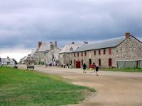
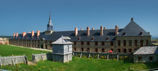
The Fortress of Louisbourg (in French, Forteresse de Louisbourg) is a National Historic Site of Canada and the location of a partial reconstruction of an 18th century French fortress at Louisbourg, Nova Scotia, Canada.
The original fortress, constructed mainly between 1720 and 1740, was one of the most extensive (and expensive) European fortifications constructed in North America. It suffered key weaknesses, since its design was directed solely toward sea-based assaults, leaving the land-facing defenses relatively weak. Captured by British colonists in 1745, it was a major bargaining chip in the negotiations leading to the 1748 treaty ending the War of the Austrian Succession, and was returned to French control. It was captured again in 1758 by British forces in the Seven Years' War, after which it was systematically destroyed by British engineers.
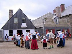
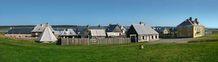
The fortress and town were partially reconstructed in the 1960s, using some of the original stonework and providing jobs for unemployed coal miners in the effort. The site is now operated by Parks Canada as a living history museum.
Contents |
Early history
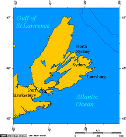
French settlement on Île Royale (now Cape Breton Island) can be traced to the early 17th century following settlements in Acadia that were concentrated on Baie Française (now the Bay of Fundy) such as at Port-Royal and other locations in present-day peninsular Nova Scotia.
The settlement at Ste-Anne
A French settlement at Ste-Anne (now Englishtown) on the central east coast of Île Royale was established in 1629 and named Fort Ste-Anne, lasting until 1641. A fur trading post was established on the site from 1651–1659, but Île Royale languished under French rule as attention was focused on the St. Lawrence River/Great Lakes colony of Canada (which then comprised parts of what is now Quebec, Ontario, Michigan, Ohio, Indiana and Illinois), Louisiana (which encompassed the current Mississippi Valley states and part of Texas), and the small agricultural settlements of mainland Acadia.
The Treaty of Utrecht in 1713 gave Britain control of part of Acadia (peninsular Nova Scotia) and Newfoundland; however, France maintained control of its colonies at Île Royale, Île St-Jean (now Prince Edward Island), Canada and Louisiana, with Île Royale being France's only territory directly on the Atlantic seaboard (which was controlled by Britain from Newfoundland to present-day South Carolina) and it was strategically close to important fishing grounds on the Grand Banks of Newfoundland, as well as being well placed for protecting the entrance to the Gulf of St. Lawrence.
Havre Louisbourg
In 1713, France set about constructing Port Dauphin and a limited naval support base at the former site of Fort Ste-Anne; however, the winter icing conditions of the harbour led the French to choose another harbour on the extreme southeastern part of Île Royale. The harbour, being ice-free and well protected, soon became a winter port for French naval forces on the Atlantic seaboard and they named it Havre Louisbourg after King Louis XIV.
Fortified town
The Fortress of Louisbourg was the capital for the colony of Île-Royale [1], and was located on the Atlantic coast of Cape Breton Island at its most southern point. The location for the fortress was chosen because it was easy to defend against British ships attempting to attack Quebec City. South of the fort, a reef provided a natural barrier, while a large island provided a good location for a battery. These defenses forced British ships to enter the harbor via a five-hundred-foot channel. The fort was built to protect Quebec City from British invasions.[2] For this reason it has been given the nicknames ‘Gibraltar of the North’ or the ‘Dunkirk of America.’ The fort was also built to protect France’s hold on one of the richest fishing grounds in the world, the Grand Banks. One hundred and sixteen men, ten women, and twenty-three children originally settled in Louisbourg.[3]
Citizens and establishments
Louisbourg was a large enough city to have a commercial district, a residential district, military arenas, marketplaces, inns, taverns and suburbs, as well as skilled laborers to fill all of these establishments.[4] For the French, it was the second most important stronghold and commercial city in New France. Only Quebec was more important to France.[5] The population of Louisbourg quickly grew. In 1719, 823 people called this maritime city their home. Seven years later, in 1726, the population was 1,296, in 1734 it was 1,616, and by 1752, the population of Louisbourg was 4,174.[6]. Of course, population growth did not come without consequences. Smallpox, a huge problem in this maritime city, ravaged the population in 1731 and 1732.[7] Despite this, Louisbourg continued to grow, especially economically.
Economy

Unlike most other cities in New France, Louisbourg did not rely on agriculture or the seigneurial system.[1] Louisbourg itself was a popular port, and was the third busiest only behind Boston, Massachusetts, and Philadelphia Pennsylvania.[8] It was also popular for its exporting of fish, and other products made from fish, such as cod-liver oil. The North Atlantic fishing trade employed over ten thousand people, and Louisbourg was seen as the ‘nursery for seamen.’ Louisbourg was an important investment for the French government because it gave them a strong commercial and military foothold in the Grand Banks. For France, the fishing industry was more lucrative than the fur trade.[9] In 1731, Louisbourg fishermen exported 167,000 quintals of cod and 1600 barrels of cod-liver oil. There were roughly 400 shallop-fishing vessels out each day vying for the majority of the days catch. Also, sixty to seventy ocean going schooners would head out from Louisbourg to catch fish further down the coast.[10] Louisbourg’s commercial success was able to bring ships from Europe, The West Indies, Quebec, Acadia, and New England.[8]
Fortifications
Louisbourg was also known for its fortifications, which took the original French builders twenty-five years to complete. The engineer behind the project was Jean-Francois du Verger de Verville. Verville picked Louisbourg as his location because of its natural barriers.[11] The fort itself cost France thirty million livres, which prompted King Louis XV to joke that he should be able to see the peaks of the buildings from his Palace in Versaille.[12] The original budget for the fort was four million livres.[13] Two and a half miles of wall surrounded the entire fort. On the western side of the fort, the walls were thirty feet high, and thirty-six feet across. The city had two gates that lead into the city known as the Dauphin gate, which is currently reconstructed, and the Queen's gate which is not. Louisbourg was also home to six bastions, two of which are reconstructed. Dauphin bastion, commonly referred to as a 'demi-bastion' for its modification, the King's bastion, Queen's bastion, Princess bastion, Maurepas bastion and the Brouillon bastion. On the eastern side of the fort, fifteen guns pointed out to the harbor. The wall on this side was only sixteen feet high and six feet across. Louisbourg was one of the “largest military garrisons in all of New France”, and many battles were fought and lives lost here because of it.[14] The fort had the embrasures to mount one hundred and forty-eight guns; however, Historians have estimated that only one hundred embrasures had cannons mounted. Disconnected from the main fort, yet still a part of Louisbourg, a small island in the harbor was also fortified. The walls on the island were ten feet high, and eight feet thick. Thirty-one twenty-four pound guns were mounted facing the harbor. The island itself was incredibly small, with room for only a few small ships to dock there, yet it provided the extra protection Louisbourg needed during the sieges of 1745 and 1758.[15]
First siege: 1745
The fortress was attacked in two major sieges: once in 1745 and the again in 1758. The first siege involved a New England force backed by a British Royal Navy squadron. The New England attackers succeeded when the fortress capitulated on June 16, 1745. A major expedition by the French to recapture the fortress led by Jean-Batiste De Roye de la Rochefoucauld Duc d'Anville the following year was destroyed by storms, disease and British naval attacks before it ever reached the fortress.
Louisbourg returned
The New Englanders' elation turned to disgust three years later, in 1748. The Treaty of Aix-la-Chapelle, which ended the War of the Austrian Succession, restored Louisbourg to France in return for the British trading post at Madras in India. The New England forces left, taking with them the famous Louisbourg Cross, which had hung in the fortress chapel. This cross was rediscovered in the Harvard University archives only in the latter half of the 20th century; it is now on long-term loan to the Louisbourg historic site.
Having given up Louisbourg, Britain in 1749 created its own fortified town on Chebucto Bay which they named Halifax. It soon became the largest Royal Navy base on the Atlantic coast and hosted large numbers of British army regulars. The 29th Regiment of Foot was stationed there; they cleared the land for the port and settlement.
Second siege: 1758
Britain's North American (American) colonies were expanding into areas claimed by France by the 1750s, and the efforts of French forces and their Indian allies to seal off the westward passes and approaches through which American colonists could move west soon led to the skirmishes that developed into the French and Indian War in 1754. The conflict widened into the larger Seven Years' War by 1756, which involved all of the major European powers.
A large-scale French naval deployment in 1757 fended off an attempted assault by the British in 1757. However, inadequate naval support the following year allowed a large British combined operation to land for the 1758 Siege of Louisbourg which ended on July 26, 1758, with a French surrender. The fortress was used by the British as a launching point for its 1759 Siege of Quebec that culminated in the Battle of the Plains of Abraham.
The fortress was systematically destroyed by British engineers in 1760 to prevent its future use by anyone. The site was abandoned at the end of the Seven Year's War.
National Historic Site
In 1961, the government of Canada, under the leadership of Victor Malm, undertook a historical reconstruction of one quarter of the town and fortifications with the aim being to recreate Louisbourg as it would have been at its height in the 1740s. The work required an interdisciplinary effort by archaeologists, historians, engineers, and architects. The reconstruction was aided by unemployed coal miners from the industrial Cape Breton area, many of whom learned French masonry techniques from the 18th century and other skills to create an accurate replica. Where possible, many of the original stones were used in the reconstruction.
Today, the entire site of the Fortress of Louisbourg, including the one-quarter reconstruction, has been designated a National Historic Site of Canada, and is operated by Parks Canada. Offerings included guided and unguided tours, and the demonstration and explanation of period weapons; these include the firing of muskets and a cannon. Puppet shows are also shown. The Museum / Caretakers Residence (c. 1935-6) within the Louisbourg National Historic Site is a classified federal heritage building on the Canadian Register of Historic Places.[16] The fortress has also greatly aided the local economy of the town of Louisbourg as it has struggled to diversify economically with the decline of the North Atlantic fishery.
See also
- Royal eponyms in Canada
Affiliations
The museum is affiliated with: CMA, CHIN, and Virtual Museum of Canada.
Notes
- ↑ 1.0 1.1 John Fortier, p. 4
- ↑ Robert Emmet Wall. “Louisbourg ,1745” in The New England Quarterly, Vol. 37, No. 1 (March 1964), page 64 – 65.
- ↑ A.J.B Johnston. “From Port de peche to ville fortifiee: The Evolution of Urban Louisbourg 1713–1858” in Aspects of Louisbourg. The University College of Cape Breton Press, Sidney Nova Scotia 1995, page 4
- ↑ “The Fortress of Louisbourg and its Cartographic Evidence” in Bulletin of the Association for Preservation Technology, Vol. 4, No 1 (1972), page 3.
- ↑ R.H Whitbeck. “A Geographical Study of Nova Scotia” in Bulletin of the American Geographical Society, Vol. 46, No. 6 (1914), page 413.
- ↑ B.A. Balcom. “The Cod Fishery of Isle Royale, 1713-58” in Aspects of Louisbourg. The University College of Cape Breton Press, Sidney Nova Scotia 1995, page 171
- ↑ Christopher Moore, The Louisbourg Portraits, Toronto, Ontario: McClelland and Stewart Ltd, 2000
- ↑ 8.0 8.1 Fortier, p. 3
- ↑ A.J.B Johnston. “From Port de peche to ville fortifiee: The Evolution of Urban Louisbourg 1713–1858” in Aspects of Louisbourg. The University College of Cape Breton Press, Sidney Nova Scotia 1995, page 4
- ↑ Christopher Moore, The Louisbourg Portraits, Toronto, Ontario: McClelland and Stewart Ltd, 2000, page 109, 261-270.
- ↑ An Appearance of Strength The Fortification of Louisbour by Bruce W. Fry pg 20
- ↑ Fortier, p. 11
- ↑ B.A. Balcom. “The Cod Fishery of Isle Royale, 1713-58” in Aspects of Louisbourg. The University College of Cape Breton Press, Sidney Nova Scotia 1995, page 171.
- ↑ The Fortress of Louisbourg and its Cartographic Evidence” in Bulletin of the Association for Preservation Technology, Vol. 4, No 1 (1972), page 3
- ↑ Christopher Moore, The Louisbourg Portraits, Toronto, Ontario: McClelland and Stewart Ltd, 2000), page 66.
- ↑ Canadian Register of Historic Places
References
- Drake, Samuel Adams (1891). The Taking of Louisburg 1745. Boston: Lee and Shepard Publishers. (reprinted by Kessinger Publishing ISBN 9780548622346)
- Fortier, John (1979). Fortress of Louisbourg. Toronto: Oxford University Press.
- Johnson, A.J.B (2008). Endgame
- McLennan, J.S (2000 [1918]). Louisbourg: From its Foundation to its Fall, 1713-1758. Halifax: The Book Room Limited.
- Parks Canada (undated). Fortress of Louisbourg National Historic Site brochure.
- Wood, William. The Great Fortress: A Chronicle of Louisbourg 1720–1760 (text version from Project Gutenberg, audiobook from LibriVox)
External links
- Fortress of Louisbourg National Historic Site - Parks Canada
- Louisbourg Institute
- Account of New England vessels used against Louisbourg in 1745
- An essay on Fortress Louisbourg
|
||||||||||||||||||||||||||||||||||
|
|||||||||||||||||||||||||||||||||||||||||||||||||||||||
|
||||||||||||||
|
||||||||||||||

|
|||||||||||